
Persistent stratus clouds have kept temperatures lower than anticipated up to the end of the week, Saturday afternoon. The clouds are expected to thicken as the weather turns wet again on Sunday. For the latest updates, watch the video forecast available online.
A lingering, gray overcast has resulted in temperatures peaking only in the mid-60s at best through Saturday afternoon, with limited sunshine and a very gentle breeze. The clouds will persist, and temperatures will remain in the 50s as we await the arrival of the next round of showers by the end of the week. The highest probability of rain on Sunday will be predominantly to the south of Interstate 20 during the afternoon and evening.
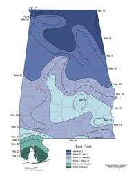
The showers will arrive in two main waves: scattered light showers and drizzle from 3 a.m. to 10 a.m., followed by heavier, more consistent rain mainly over areas south of Tuscaloosa, Birmingham, Alabaster, Talladega, and Anniston. Historically, Birmingham typically experiences its final freeze of the year in late March, with some colder areas often seeing a freeze into early April. A surge of colder air originating from northern Canada is set to hit the South by Sunday night and Monday, resulting in temperatures feeling more like mid-February than mid-March early next week.
This Monday high temperature is forecasted to reach the mid-50s before a freeze on Tuesday morning. It’s advisable to protect any plants as this upcoming freeze could be detrimental to vegetation.